
膨大な量のCRMオブジェクトを簡単に操作できるようにする、細心の注意を払ったユーザーインターフェース。 100%モバイル対応。
A large map with objects grouped in layers and sublayers, with integrated autofill searching in addresses and names in all records at once.
Data table with extensive filters and 2-way sync with the map.
Your custom objects and fields automatically become viewable and editable in Mapsly and can appear in map marker’s labels, in map popups and as table view columns.
Mapsly automatically calculates distance from an anchor point you indicate to all objects, so you can use it in the table filter, or to update records.
Isochrones: draw lines of equal travel time around a point, or circles of equal direct distance from a point.
Record’s map popup offers a range of useful actions like Google street view and shortcut to the record’s CRM page.
必要な方法でデータを確認できるようにすることで、競争上の優位性を強化するように設計されています。 地理データに隠された知識を明らかにします。
Adjust map markers for any object: its icon, color or size.
Create layers of records that match certain criteria and assign custom markers to them. Define criteria with Visual formula builder based on records' field values.
Create map filters to hide points that don't match your criteria. Apply filters to layers and your table view.
Adjust map transparency, change default map tiles to reduce the number of objects, and adjust point clustering settings.
Choose data fields to be shown in marker’s name, hover-hint or pop-up, or in the data-grid.
Create an interactive map shared by link, with a subset of your CRM data based on URL variable. Add multi-level filters, custom permissions and custom-styled tiles. Use on your website as a store locator or in customer portals.
Define viewing/editing capabilities per custom map.
Embed parameter-based custom maps into your own customer portal or publish on your website.
MapslyはCRMと連携して動作し、販売管轄の管理、見込み客の一括追加、CRMのワークフローと自動化の呼び出しを支援します。
Draw your territories on the map or build them from a geo-library (states/provinces, counties, postal code areas). Then, Mapsly will be assigning your records to territories and sending this data to your CRM entirely automatically.
Learn more »
Edit your CRM data right on the map including lookup and multi-select lookup fields. Your changes are synced with your CRM in real time.
Mass-update objects filtered by any criteria like territories, distance and/or any other combination of conditions.
Find businesses by keywords, bulk-add them as leads or accounts by using our lasso tool and native API integration with your CRM.
Learn more »
Trigger CRM workflows and build processes around the map by using Mapsly’s capabilities to update CRM data in real time and through embedding popup frames with custom links.
For every address in your CRM (including those with mistakes and missing zip codes) Mapsly saves to CRM the 'clean' address, county and coordinates so you can find closest records or deduplicate leads.
クラス最高のルーティングAPIとフリート管理APIを使用して、販売員をナビゲートし、現場担当者の運用効率を向上させ、燃料を節約します。完全にモバイル対応。
Optimize your route by auto-reordering the points in the most optimal way based on the travel mode (fastest or shortest car driving, truck driving, walking or cycling).
Adjust trucks’ and their payload’s parameters to avoid unsuitable roads.
Routing based on live and historic traffic with adjustable departure time.
One-click export to your favorite navigation app like Google Maps, Apple Maps, or Waze.
Powerful lasso tool to easily manipulate route points, on desktop or mobile.
Hybrid public transit travel mode allows for roles that combine multiple modes of public transport and fine-tuning such as maximum walking distance or walking speed.
特徴 | 説明 |
---|---|
地理位置情報で公共交通機関のオプションを見つけます。 | 広告に基づいて、近くの駅を検索し、その地域で利用できる公共交通機関の情報(交通路線や出発時刻など)を特定し、特定の時間枠内で人が公共交通機関で移動できる距離を調べます。 |
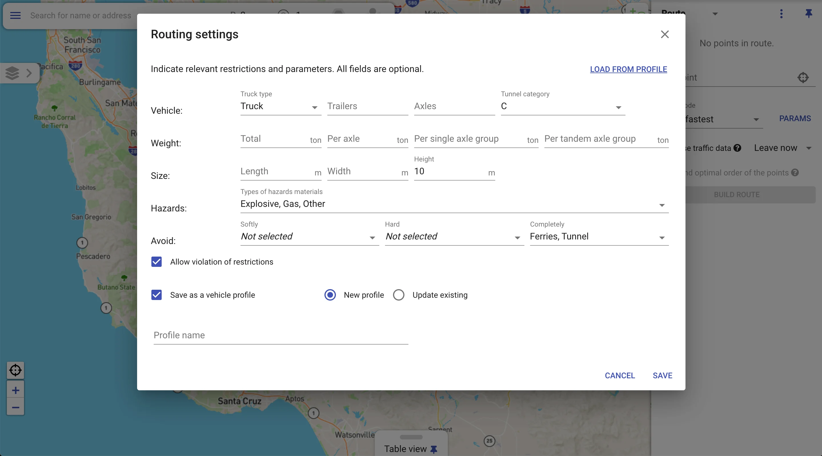
公共交通機関のルートを取得します。 | 開始アドレスと終了アドレスに基づいて、特定の都市または大都市圏で利用可能なすべての交通機関の種類を利用した公共交通機関のルートを表示します。
次の方法で、さまざまなユースケースに合わせて輸送ルートの計算を調整できます。
|
使用する Mapslyオートメーションスイート マップの周りにプロセスを構築するには、 最適なレコードを見つける 走行距離で、 ストップにチェックイン ジオフェンスを使用するか、選択したレコードから連絡先リスト(CRMキャンペーン)を作成します。
MapslyはCRMのデータ構造に合わせて調整し、カスタムオブジェクトとフィールドを自動的に保存します。大規模なデータセットのパフォーマンスを犠牲にすることなく。
CRM、EPR、独自システムなど、任意の数またはタイプのデータソースから同時にデータをインポートします。一般的なCRMのビルド済みコネクタを使用するか、独自のコネクタを作成します。
カスタムフォームを作成し、ポップアップを数分でマップし、JavaScriptのさまざまなイベントハンドラーでAPIコールアウトとのリアルタイムデータ交換を実装します。
Mapslyの統合IDEを使用して、外部APIを呼び出し、複雑な計算を実行し、Masplyのマップ、データベース、フォームにアクセスするJavaScriptコードを記述します。
カスタムコードは、UI(Form.OnOpen、Button.OnClickなど)、データインポート(ImportSession.OnFinishなど)、またはスケジュールに関連するイベントハンドラーで実行できます。
Mapslyメタ言語を使用して、ポリゴン、ライン、テキストラベルなどのビジュアルプリミティブからオブジェクトを描画する方法を定義して、マップ上に独自のオブジェクトをプロットします。
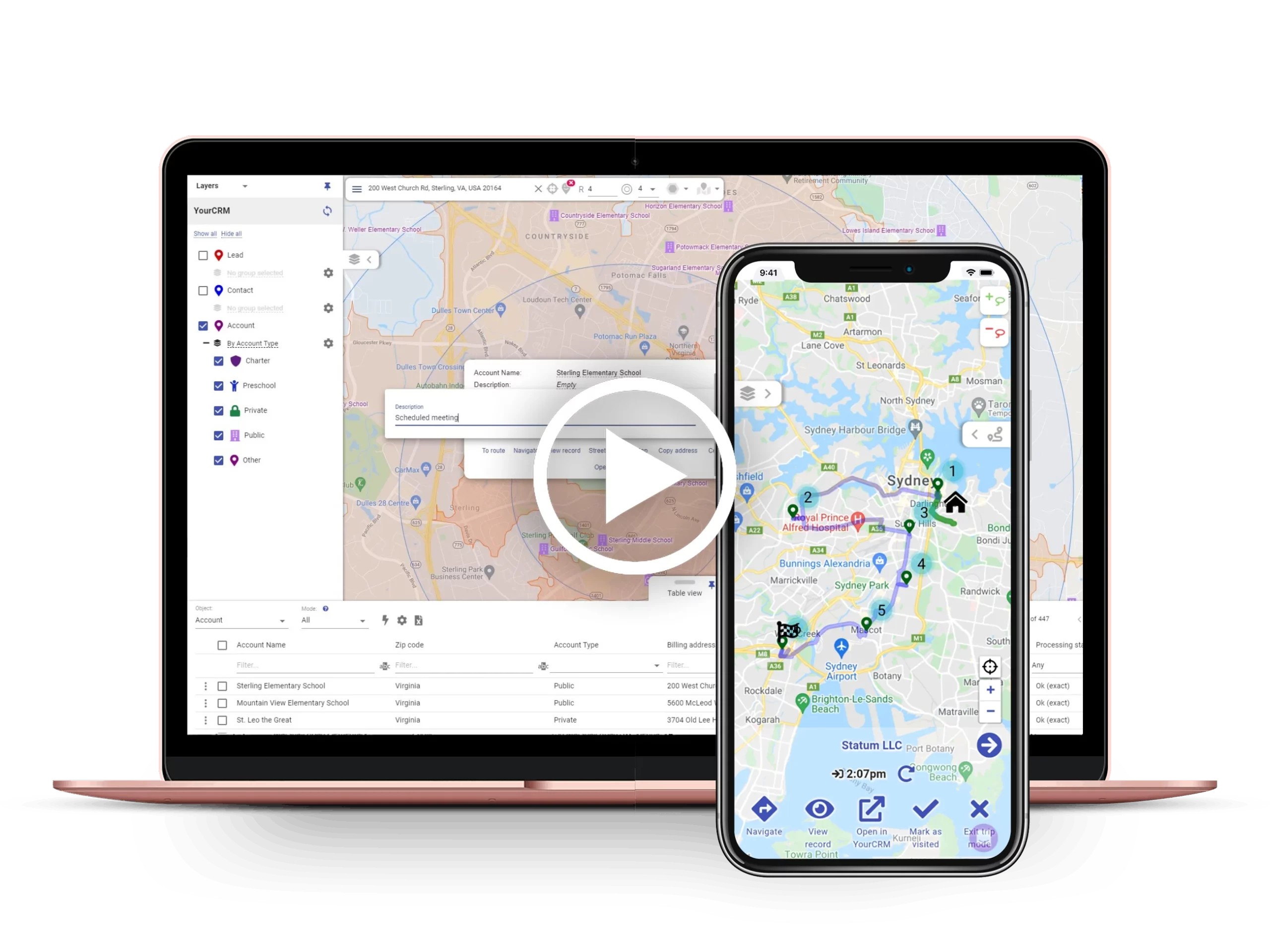
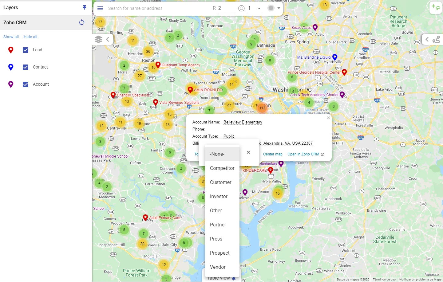
Mapslyは、主要なジオインテリジェンスプラットフォームに期待できるあらゆる統合オプションを提供します。
MapslyとCRM間のインスタントデータ同期。
データのインポート頻度を調整して、CRM APIクレジットの消費を最適化します。
一度に複数のデータソースからインポートします。
CRM内でMapslyを使用-個別のログイン/パスワードは必要ありません。
ライブ追跡:Mapsly APIを使用して、リアルタイムでフリートを追跡します。
自動データ品質管理は、間違ったアドレスや欠落しているアドレスを明らかにするのに役立ちます。
Mapslyは、プラットフォームの広範なAPIの上に構築されたアダプターを介して、幅広いデータ同期オプションをサポートします。
Zapier経由の40以上のCRMコネクタ。より多くがすぐに来ると。
文書化された強力なAPIにより、カスタムデータソースをMapslyとリアルタイムデータ同期で統合できます。
Mapsly の IDE を使用してスケジュールされたイベント トリガーの JavaScript コードを追加し、カスタム データ交換、リアルタイム API コールアウト、シリアル化されたオブジェクトのインポートなどを実装します。
FTPフォルダーからのデータの自動インポート(一方向統合)。
スプレッドシートのアップロード(一方向の手動データインポート)。
お客様のデータのセキュリティは#1の優先事項です。そのため、すべてのお客様のデータは暗号化され、プラットフォームはOWASP ASVSに従って定期的にセキュリティ評価を受けます。
クッキー | 期間 | 説明 |
---|---|---|
cookielawinfo-チェックボックス-分析 | 11ヶ月 | このCookieは、GDPRCookieConsentプラグインによって設定されます。 Cookieは、「分析」カテゴリのCookieに対するユーザーの同意を保存するために使用されます。 |
cookielawinfo-チェックボックス-機能 | 11ヶ月 | Cookieは、「機能」カテゴリのCookieに対するユーザーの同意を記録するためにGDPRCookieの同意によって設定されます。 |
cookielawinfo-チェックボックス-必要 | 11ヶ月 | このCookieは、GDPRCookieConsentプラグインによって設定されます。 Cookieは、「必要」カテゴリのCookieに対するユーザーの同意を保存するために使用されます。 |
cookielawinfo-チェックボックス-その他 | 11ヶ月 | このCookieは、GDPRCookieConsentプラグインによって設定されます。 Cookieは、「その他」カテゴリのCookieに対するユーザーの同意を保存するために使用されます。 |
cookielawinfo-チェックボックス-パフォーマンス | 11ヶ月 | このCookieは、GDPRCookieConsentプラグインによって設定されます。 Cookieは、「パフォーマンス」カテゴリのCookieに対するユーザーの同意を保存するために使用されます。 |
Viewed_cookie_policy | 11ヶ月 | Cookieは、GDPR Cookie Consentプラグインによって設定され、ユーザーがCookieの使用に同意したかどうかを保存するために使用されます。個人データは保存されません。 |