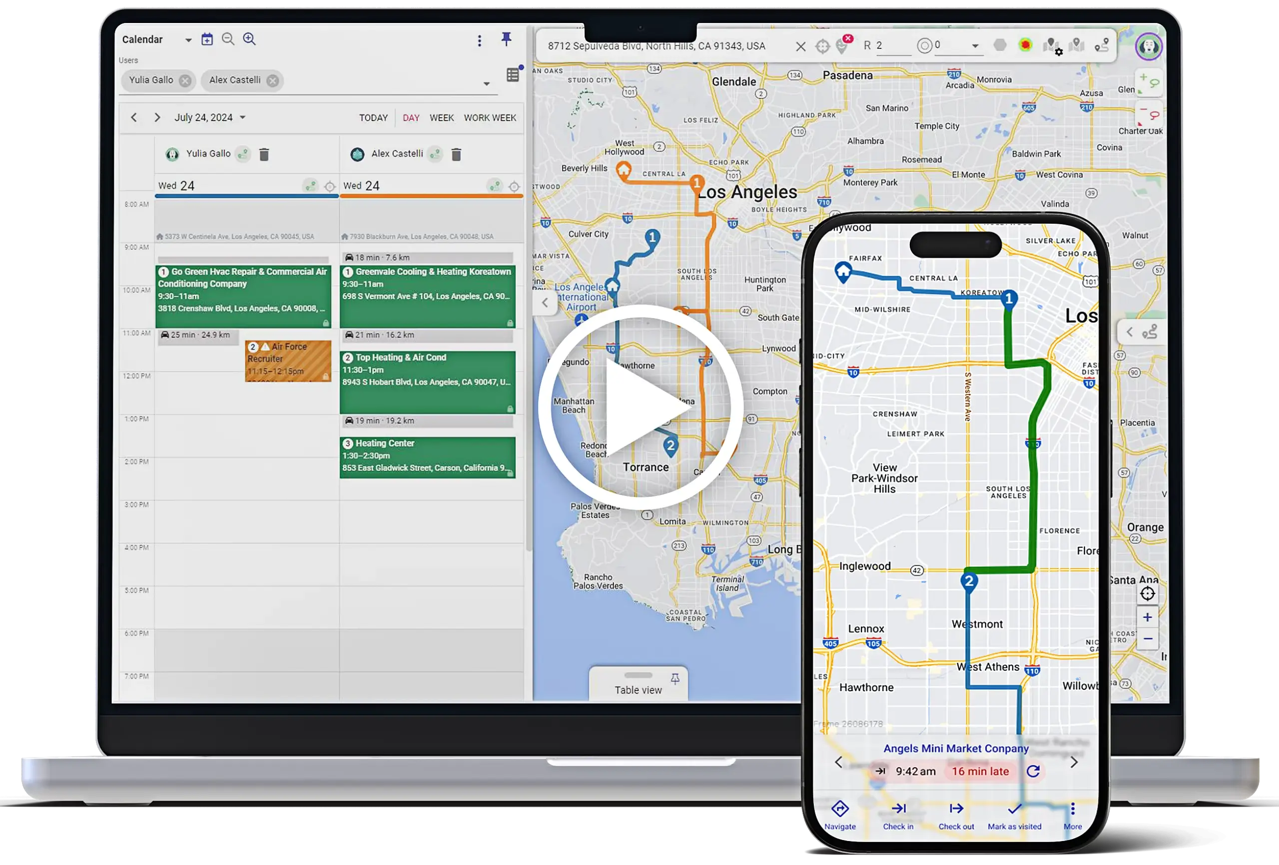
Lorem ipsum dolor sit amet, consectetur adipiscing elit. Ut elit tellus, luctus nec ullamcorper mattis, pulvinar dapibus leo.
Add geo-features to any CRM, ERP, e-commerce or other IT system: customizable map, optimized routing, territory management, prospect discovery & no-code automation suite with built-in geo-functions.
Meticulously thought-out user interface that makes working with vast amounts of CRM objects a breeze. 100% mobile ready.
A large map with objects grouped in layers and sublayers, with integrated autofill searching in addresses and names in all records at once.
Data table with extensive filters and 2-way sync with the map.
Your custom objects and fields automatically become viewable and editable in Mapsly and can appear in map marker’s labels, in map popups and as table view columns.
Mapsly automatically calculates distance from an anchor point you indicate to all objects, so you can use it in the table filter, or to update records.
Isochrones: draw lines of equal travel time around a point, or circles of equal direct distance from a point.
Record’s map popup offers a range of useful actions like Google street view and shortcut to the record’s CRM page.
Designed to strengthen your competitive advantages by helping you see your data the way you need it. Reveal knowledge hidden in your geo-data.
Adjust map markers for any object: its icon, color or size.
Create layers of records that match certain criteria and assign custom markers to them. Define criteria with Visual formula builder based on records' field values.
Create map filters to hide points that don't match your criteria. Apply filters to layers and your table view.
Adjust map transparency, change default map tiles to reduce the number of objects, and adjust point clustering settings.
Choose data fields to be shown in marker’s name, hover-hint or pop-up, or in the data-grid.
Create an interactive map shared by link, with a subset of your CRM data based on URL variable. Add multi-level filters, custom permissions and custom-styled tiles. Use on your website as a store locator or in customer portals.
Define viewing/editing capabilities per custom map.
Embed parameter-based custom maps into your own customer portal or publish on your website.
Mapsly works in tandem with your CRM to help you better manage sales territories, bulk-add prospects to it and invoke your CRM’s workflows and automations.
Draw your territories on the map or build them from a geo-library (states/provinces, counties, postal code areas). Then, Mapsly will be assigning your records to territories and sending this data to your CRM entirely automatically.
Learn more »
Edit your CRM data right on the map including lookup and multi-select lookup fields. Your changes are synced with your CRM in real time.
Mass-update objects filtered by any criteria like territories, distance and/or any other combination of conditions.
Find businesses by keywords, bulk-add them as leads or accounts by using our lasso tool and native API integration with your CRM.
Learn more »
Trigger CRM workflows and build processes around the map by using Mapsly’s capabilities to update CRM data in real time and through embedding popup frames with custom links.
For every address in your CRM (including those with mistakes and missing zip codes) Mapsly saves to CRM the 'clean' address, county and coordinates so you can find closest records or deduplicate leads.
By using best-in-class routing and fleet management APIs to help you navigate your sales force, improve operational efficiency of your field reps and save on fuel. Entirely mobile ready.
Optimize your route by auto-reordering the points in the most optimal way based on the travel mode (fastest or shortest car driving, truck driving, walking or cycling).
Adjust trucks’ and their payload’s parameters to avoid unsuitable roads.
Routing based on live and historic traffic with adjustable departure time.
One-click export to your favorite navigation app like Google Maps, Apple Maps, or Waze.
Powerful lasso tool to easily manipulate route points, on desktop or mobile.
Hybrid public transit travel mode allows for roles that combine multiple modes of public transport and fine-tuning such as maximum walking distance or walking speed.
Feature | Description |
---|---|
Discover public transit options in a geolocation. | Based on an adвress, search for nearby stations, determine what public transit information is available in the area (e.g. transit lines and departure times), and discover how far a person can travel by public transit within a certain time frame. |
Get public transit routes. | Based on start and end addresses, view public transit routes making use of all available transit types in a given city or metropolitan area.
You can tailor transit route calculation for different use cases by:
|
Mapsly is a meta-data & event driven platform designed to seamlessly integrate into your IT landscape and adapt to the way you work, not limit you by predefined functionality.
Mapsly adjusts to data structure in your CRM and automatically stores custom objects and fields. Without compromising performance on large datasets.
Import data from any number or type of data sources simultaneously: CRMs, EPRs or proprietary systems. Use pre-built connectors for popular CRMs or create your own.
Create custom forms and map popups in minutes and implement real-time data exchange with API callouts in various event handlers in JavaScript.
Use Mapsly’s integrated IDE to write JavaScript code that calls out external APIs, performs complex calculations and accesses Masply’s map, database and forms.
Custom code can run in event handlers related to UI (like Form.OnOpen, Button.OnClick), data import (like ImportSession.OnFinish) or by schedule.
Plot your own objects on the map by defining how an object should be drawn out of visual primitives like polygons, lines and text label(s) using Mapsly meta language.
Mapsly offers a full range of integration features that you may expect from a leading geo-intelligence platform.
Instant data sync between Mapsly and your CRM.
Adjust frequency of data import to optimize consumption of your CRM API credits.
Import from multiple data sources at once.
Use Mapsly inside your CRM - no need for separate logins/passwords.
Live Tracking: use Mapsly API to track your fleet in real-time.
Automatic data quality control helps you reveal wrong and missing addresses.
Mapsly supports a wide range of data sync options via adapters built on top of the platform’s extensive API.
2-way native API integration to connect Mapsly to ZohoCRM or SalesForce in minutes.
A powerful well-documented API allows any custom data source to be integrated with Mapsly with real-time data sync.
Add scheduled and event-triggered JavaScript code using Masply’s IDE to implement custom data exchange, real-time API callouts, import serialized objects and much more.
Security of our customers’ data is our #1 priority, that’s why all customer data is encrypted, and the platform undergo regular security assessment in accordance with OWASP ASVS.
340 S LEMON AVE, WALNUT,
CA 91789