




What Airtable can and can’t do with maps
Airtable’s native Map extension plots records as pins. Point it at a field with addresses or coordinates, add your own Google Maps API key, and it geocodes and shows your locations as clickable pins, with a few marker-styling options.
But that’s as far as it goes. The native map view is display-only: it can’t optimize routes, plan multi-day or multi-user trips, manage territories, or drive a mobile field app. It also won’t write anything back to your base. For a team that actually drives to those locations, dropping pins on a map is the easy part. The hard part is everything that comes after.
Here’s where the native extension stops, and a tool like Mapsly takes over:
| Capability | Airtable native Map extension | Airtable + Mapsly |
|---|---|---|
| Plot records on a map | Yes | Yes |
| Geocode addresses | Manual, needs your own Google Maps API key | Automatic: cleans addresses, fills missing ZIP/county |
| Optimized multi-stop routing | No | Yes |
| Multi-day & multi-user planning | No | Yes |
| Car, truck, bike & walking modes | No | Yes, with truck restrictions |
| Territory management & auto-assign | No | Yes |
| No-code automation | No | Yes |
| Mobile app with check-in | No | Yes |
| Real-time sync with your base | View-only | Yes, real-time |
See your Airtable records on a live map view
Mapsly gives you an interactive map view of your Airtable base, and you don’t need an API key of your own. Every record with an address or coordinates becomes a pin.
Filter and color-code. Style pins by any Airtable field: status, owner, priority, deal size, service type.
Edit in place. Update records right in the map pop-up, or mass-update them in the table view.
Draw territories. Sketch or import territories, and see which records fall inside each one.
Add context. Overlay demographic and location data, including US Census.
Share and embed. Put a live map in front of teammates and partners.
Plan optimized routes from your Airtable data
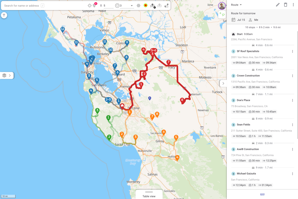
This is the part Airtable can’t do at all. Select the records you want to visit (with the map lasso, a filter, or a single click on a record), and Mapsly sequences them into the most efficient route using live and historical traffic.
Full-team planning. Multi-day, multi-user routes across your whole field team.
Real-world constraints. Time windows, open hours, job durations, required skills, and vehicle limits.
Every travel mode. Car, truck, bicycle, and walking, with truck restrictions to keep drivers off unsuitable roads.
Long-haul and calendar-aware. Overnight-rest routes, and new visits that fit around existing meetings from your CRM, Google Calendar, or Outlook.
Manage territories from your Airtable base
Draw territories on the map or import them, then let Mapsly auto-assign Airtable records and reps to the right areas. As your base changes, assignments keep up, so coverage stays balanced without manual sorting.
Automate field work, no code
Mapsly includes a no-code automation suite that reacts to what happens in the field. Trigger workflows on a check-in, a form submission, or a change to an Airtable field, then update records, notify a manager, or launch the next step automatically. No developer required.
Take it to the field
Mapsly’s mobile app turns the plan into action. Reps navigate their optimized route, check in and out of stops, and capture exactly the data you need with configurable forms. What they record flows back to your base in real time, and managers can watch live location and planned-vs-actual performance.
How Airtable and Mapsly stay in sync
Mapsly replicates your Airtable tables and fields, and new or updated records are pulled from Airtable in real time. Changes made in the field write back to your base, so the map and routes always reflect what’s actually in your tables. Airtable stays your source of truth; Mapsly is the geographic and field-execution layer around it.
How to map your Airtable data
1. Connect. Link your Airtable base to Mapsly. It replicates your tables and fields in minutes.
2. Map. Mapsly cleans and geocodes your addresses automatically, then plots your records.
3. Route. Select records and build your first optimized route.
4. Scale. Draw territories, set up a check-in form, and add automation as you go.
FAQ
Does Airtable have a map view?
Yes. Airtable has a native Map extension that plots records as pins using your own Google Maps API key. It’s view-only, though: it doesn’t optimize routes, manage territories, or sync changes. For those, you need a mapping layer like Mapsly.
Can you put Airtable data on Google Maps?
You can copy addresses into Google Maps by hand, but it caps out around 10 stops, doesn’t optimize a full field day, and doesn’t stay in sync with your base. Mapsly maps your Airtable records directly and keeps them updated in real time.
Can you plan routes from Airtable?
Yes. With Mapsly, you can build optimized multi-stop, multi-day routes straight from your Airtable records, with live traffic, time windows, and skill or vehicle constraints taken into account.
Does Airtable have built-in route optimization?
No. Airtable’s native map only displays pins. Route optimization needs an external layer such as Mapsly, which adds it with no code.
How do you map Airtable data automatically?
Connect your Airtable base to Mapsly and it replicates your tables and fields, then cleans and geocodes your addresses and plots your records on an interactive map, usually within minutes.
Is Mapsly’s Airtable integration no-code?
Yes. Connecting Airtable, mapping records, building routes, and setting up automations all happen without writing any code.
Want to see it on your own Airtable data? 빠른 세션을 예약하세요 우리 솔루션 엔지니어와 함께.